HomeAuto West Africa Coastlines Vanish Up to 30 Feet Per Year, Harvard Study Reveals
West Africa Coastlines Vanish Up to 30 Feet Per Year, Harvard Study Reveals
September 9, 2026:
David Trilling/Salatainstitute.harvard.edu
Some stretches of the West African coast are losing up to 30 feet (9.1 meters) of land a year to the Atlantic Ocean — a rate fast enough to bury the average American home in sand and saltwater within months. A three-year investigation by Harvard’s Salata Institute for Climate and Sustainability, published Tuesday in the Harvard Gazette, concludes that the region’s most visible response to that loss — stone barriers called groynes — protect one community by accelerating the erosion of the next, and that governments weighing their limited options should rethink the assumption that hard engineering can win. The research was conducted with partner universities in Ghana, Côte d’Ivoire, and Nigeria, and its findings were delivered directly to government planners in Accra, Abidjan, and Lagos during a series of policy dialogues in June 2026. West Africa’s Gulf of Guinea nations contribute a negligible share of the greenhouse gas emissions that drive sea-level rise — Ghana’s share of global GHG emissions amounts to less than a tenth of a percent — yet they are absorbing some of the world’s most severe erosion costs, with just three Nigerian states losing an estimated $9.7 billion to coastal degradation in a single year, according to a World Bank Nigeria coastal report.
Why Keta’s Reprieve Belongs to Someone Else
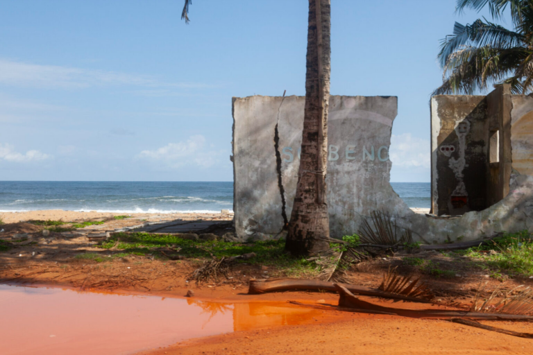
Josephine Domevenu lost her clothing and snack kiosk to the Atlantic overnight about two years ago. Within months, the sea had reached her doorstep in Keta, a narrow strip of land in eastern Ghana wedged between the open ocean and a flood-prone lagoon. A storm then drove seawater through several rooms of her house and overturned her grandparents’ graves in the garden, filling the cinderblock tombs with sand.
“The sea is angry with us,” Domevenu, 25, told Harvard researchers.
Today there is one room left standing, and something that might look like good news: Ghana’s government has constructed several dozen groynes this year — stone barriers set at right angles to the shoreline, roughly 700 feet (213 meters) apart, designed to interrupt the current and hold the beach in place. They appear to be working on Domevenu’s stretch of coast.
Coastal engineers have a name for what happens next. Terminal groyne syndrome is the well-documented tendency of a groyne field to protect the beach on its updrift side — trapping sand that would otherwise continue moving — while starving the beaches below it of that same sediment. The result is that every groyne field has an endpoint, and at that endpoint, erosion accelerates beyond it.
Not far beyond the last groyne in Keta, Kwashiwor Dansa, 62, who has smoked anchovies, mackerel, and sardines over sugarcane husks for more than 30 years, is watching the sea close in on her home. She says the erosion on her stretch of beach began this spring, when the groynes arrived updrift.
“The sea is getting closer now,” Dansa said. “I’m afraid. If the builders are not in a hurry to put one here, the sea will take our house in weeks” — a fear documented by the Harvard research team in Keta.
Kwasi Appeaning Addo, a coastal morphologist at the University of Ghana and a collaborator on the Harvard study, was direct about the limits of what governments are doing. “They are a temporary fix,” he said. “People are upset, so they shout at politicians and politicians dump boulders. But it just shifts the problem downdrift. We are not managing erosion; we are fighting erosion, and it’s a fight we cannot win” — a conclusion drawn from the project’s fieldwork.
Addo pointed to Benin as a working alternative: engineers there have rebuilt beaches by dredging sand from the ocean floor and planting mangroves to anchor it — a nature-based approach that works with sediment transport rather than against it.
What Is Driving the Acceleration
The Gulf of Guinea’s erosion problem is not new, but its pace has changed sharply. Keta’s beaches have always shifted: an eastward-racing current both strips away and redeposits sand in an ancient cycle. What disrupted that balance was a century of human intervention. Ports, dams, and harbour jetties along the West African coast interrupt the longshore transport of sand — the wave-driven conveyor belt that naturally replenishes beaches downdrift. Sand that once traveled freely is now trapped behind dams like Ghana’s Akosombo on the Volta River, or deflected offshore by harbour structures, and beaches starve.
Now climate change has changed the underlying physics.
Sea levels in the Gulf of Guinea are rising at 3.89 millimeters (0.15 inches) per year along the coast — about 10 percent above the global average of 3.52 mm/yr (0.14 in/yr). A 2025 study published in Remote Sensing identified a 2015 regional sea-level regime shift beginning in 2015: the mean coastal rate jumped from 2.93 mm/yr (0.12 in/yr) before 2015 to 5.4 mm/yr (0.21 in/yr) after, with localized rates on the eastern Gulf coast surpassing 10 mm/yr (0.39 in/yr) — more than double the global mean. The driver of this acceleration is not thermal expansion but ocean mass increase from intensified river discharge into the Gulf, tied to enhanced monsoon precipitation. More rain in the interior means more water flowing to the coast, pushing sea levels up locally beyond what global warming alone would predict.
Since regional sea-level rise has tripled since the mid-20th century across the Gulf of Guinea, communities that adapted once — building groynes, elevating structures, migrating slightly inland — now face a moving baseline that their previous adaptations did not account for.
In Lagos, the situation is compounded by land subsidence: the ground under parts of the city is sinking at estimated rates of 2 to 87 mm/yr (0.08 to 3.4 in/yr) in the most vulnerable areas, driven by groundwater extraction and construction on landfill, as noted in research on GoG sea level variability. For residents, the “sea level” they experience is the combination of absolute sea-level rise and land sinking beneath them — a total that in some Lagos neighborhoods significantly exceeds the global average.
Lagos: A City With Nowhere to Put Its Most Vulnerable
In the Okun Alfa neighborhood of Lagos — Nigeria’s largest city, home to more than 15 million people — the Atlantic has advanced roughly half a mile (0.8 km) inland since the 1990s. Harvard researchers attribute part of that acceleration to a luxury development built on an artificial island several miles to the west, which altered the flow of sand along the coast, diverting sediment away from Okun Alfa’s shore. At the last groyne in the neighborhood, the current curls back toward the land and scours away a neighborhood block by block.
At least once a week, high tide carries the Atlantic over the beach and past a mound of sand and cinderblocks that residents have piled at the top of Baale Street, reaching the sandbags that Kudirat Abdulateef has stacked outside her shop and home.
“The sea is destroying my shop, my home. It is punishing my efforts to stop the water. But I have nowhere else to go,” Abdulateef said. “I dream about the water. Things were not like this before” — a sentiment captured in the Harvard field research.
In Lagos, a shortage of buildable land makes relocation largely hypothetical for the city’s poorest residents. Robert Paarlberg, a political scientist and associate at Harvard’s Weatherhead Center who collaborated on the project, identified the collision of forces converging on these communities. “Not only are climate risks increasing, but population growth on these coasts is surging and putting more people at risk,” he said. “There is a demographic challenge as well as an atmospheric challenge, and the collision between these two is what’s creating the difficult policy choices these governments face today” — an observation documented in the Gazette account.
Just offshore, the research team documented Makoko — a community of thousands built on wooden stilts above a Lagos lagoon, where residents navigate to their homes by canoe. Mokolade Johnson, a landscape architect at the University of Lagos and a project collaborator, argued that Makoko, for all its lack of formal infrastructure, models something governments cannot yet offer their coastal populations: a way of living with water rather than fighting it. “We must borrow ideas from the people of Makoko,” Johnson said. “We are not going to relocate to the Sahara Desert” — a view reported by the Gazette.
The Collapse of the Sea as Livelihood
The crisis extends beyond land. The Harvard study documented the simultaneous collapse of artisanal fisheries that have long provided a critical protein source across West Africa. Ocean warming is pushing fish stocks further from shore, while overfishing has depleted what remains.
One fisherman in Okun Alfa — who has worked these waters for 54 years — now stands thigh-deep in the riptide casting a net for sardines and empties it on the beach to find mostly trash, as the Harvard Gazette documented. His experience illustrates what the research team calls the double displacement facing coastal communities: loss of land and loss of livelihood, simultaneously.
The team also surveyed approximately 450 residents across Gulf of Guinea coastal communities on the psychological effects of repeated displacement and environmental loss. High rates of distress were documented, prompting the Harvard team to recommend integrating mental health care into climate adaptation plans as a standard component rather than an afterthought.
What the Research Recommends — and What It Will Cost
The Salata Institute project is notable for its emphasis on actionable options rather than documentation of harm. Working with economists at Université Félix Houphouët-Boigny in Côte d’Ivoire, the team produced cost-benefit analyses comparing hard infrastructure (seawalls, groynes) against combined strategies incorporating planned relocation, stronger building restrictions in floodplains, and nature-based protection such as mangrove restoration. In Azuretti and neighboring Port-Bouët in Côte d’Ivoire — where the coastline has retreated more than 492 feet (150 meters) since the 1990s — the analysis found that hard defenses look cost-effective in the near term but that combined strategies outperform them economically after 2050, when sea levels and storm intensity are projected to increase further.
Paarlberg outlined the full menu of available approaches: engineered defenses such as seawalls and groynes; nature-based solutions including mangrove planting and beach nourishment; managed physical retreat from the shoreline; and what he called “economic retreat” — a transition to livelihoods that do not depend on a stable coast. He argued all four should be weighed together rather than defaulting to whichever is most politically visible.
Ghana’s Minister for Fisheries and Aquaculture, who participated in the June 2026 policy dialogue in Accra, praised the multidisciplinary scope of the project, noting that climate adaptation “is not only an environmental issue but also an economic, social, and human development concern,” as reported in the Harvard Gazette coverage.
The multilateral infrastructure for this work exists. The World Bank’s West Africa Coastal Areas (WACA) program approved $246 million in December 2022 to expand coastal resilience in Ghana, Gambia, and Guinea-Bissau, and subsequently approved an additional $240 million for its WACA+ phase targeting Benin and Mauritania. But the scale of financing remains far short of the need: the World Bank estimate of $9.7 billion in documented annual losses in just three Nigerian states dwarfs what international programs have committed.
Who Pays for a Crisis They Did Not Cause
The article that the Harvard study does not write, but that its data implies, is about accountability. West Africa’s Gulf of Guinea nations contribute a negligible fraction of the greenhouse gas emissions that drive global sea-level rise and storm intensification. Ghana’s total GHG output is just 0.09 percent globally. Africa as a continent contributes just 4 percent of global CO2 emissions while absorbing some of the world’s fastest-accelerating coastal losses.
Emmanuel Akyeampong, the Ellen Gurney Professor of History and Professor of African and African American Studies at Harvard and the project’s principal investigator, has been careful to center agency over alarm. “We did not arrive with science and tell people, in many elaborate ways, that they are in trouble,” he said. “Our project instead asked what can be done with the resources actually available. Communities are eager to feel that they are not helpless” — a framing central to the project’s approach.
To make the research accessible to the communities it studied, the team built a portable “booxhibition” — an exhibition that unfolds from a box and can be strung up in coastal villages — showing maps, historical shoreline data, and future projections for six communities including Okun Alfa. The exhibition has been staged in Azuretti, Côte d’Ivoire, and other sites.
Supriya Ambwani, a research associate at the Critical Landscapes Design Lab and a project contributor, described its intent: “It feels like a hopeless situation. But once you start thinking of solutions, it creates something to work toward. Even if you don’t agree with all the ideas, it prompts people to engage differently. If we don’t imagine what the future could look like, we’re going to struggle to get there” — a message the team has brought to communities across the Gulf of Guinea.
For Josephine Domevenu, the policy framework resolves into something more immediate: one room left standing, a groyne holding for now, and the knowledge that the ocean has already taken everything she built from scratch, twice.
Frequently Asked Questions
Why does building groynes to stop coastal erosion sometimes make the problem worse?
Groynes interrupt the natural movement of sand along a shoreline — a process called longshore drift — by trapping sediment on their updrift side. That trapped sand no longer reaches the beaches further down the coast, which then erode faster. Coastal engineers call the result “terminal groyne syndrome”: the community protected by the last groyne in a field often sees accelerated erosion immediately beyond it. This is not a flaw in groyne design; it is the predictable consequence of stopping a sediment transport system mid-flow without extending the intervention the entire length of the affected coast. The Harvard research documents this groyne effect in real time in Keta, Ghana, where one community’s new groynes appear to be accelerating erosion outside another resident’s home.
How much has sea-level rise accelerated in the Gulf of Guinea, and what is driving it?
Sea levels along the Gulf of Guinea coast are rising at 3.89 mm (0.15 inches) per year, about 10 percent above the global average. But a 2025 study in Remote Sensing found that a significant acceleration began around 2015, with localized rates on the eastern coast now exceeding 10 mm (0.39 inches) per year — more than double the global mean. Unusually, the primary driver of this acceleration is not thermal expansion of the ocean (the standard global mechanism) but an increase in ocean mass driven by intensified rainfall and river discharge into the Gulf. More monsoon rain flows to the coast, and the sea rises faster locally than global averages would predict.
What does “managed retreat” mean, and why is it so difficult for West African coastal communities?
Managed retreat means the planned, government-supported relocation of people and structures away from a coastline that is no longer safe to inhabit, with the sea allowed to occupy the vacated land. In countries with strong land-rights systems and government financing capacity, it can involve compensation, relocation housing, and phased timelines. In West Africa’s Gulf of Guinea, it faces severe practical constraints: Lagos has a severe shortage of buildable land for the hundreds of thousands of residents most at risk; many coastal communities have no formal land titles, making compensation difficult to structure; and national governments lack the fiscal capacity to fund large-scale buyout programs. The Harvard research argues that managed retreat should be on the table as one of four approaches — alongside hard defenses, nature-based protection, and economic transition — rather than treated as a last resort after all other options have failed, according to its policy framework.
West Africa contributes little to global greenhouse gas emissions — who is responsible for covering these adaptation costs?
Ghana generates just 0.09 percent of global greenhouse gas emissions, and Africa contributes just 4 percent globally of CO2 while experiencing some of the world’s fastest erosion rates. The international financing that exists — including the World Bank’s WACA program, totaling several hundred million dollars across the region — is far smaller than the documented losses: one World Bank study put annual coastal degradation costs at $9.7 billion in just three Nigerian states in a single year. The Harvard study does not assign legal liability, but the researchers note that the communities they documented did not cause the crisis they are living through. International climate finance — including commitments made under the Paris Agreement’s loss-and-damage framework — represents the primary mechanism for closing this gap, though current funding levels fall well short of documented need.