HomeAuto Soaked by Lala, Hawaii Faces Outsized Flood Risk From Weaker Tropical Storm Moke
Soaked by Lala, Hawaii Faces Outsized Flood Risk From Weaker Tropical Storm Moke
August 24, 2026:
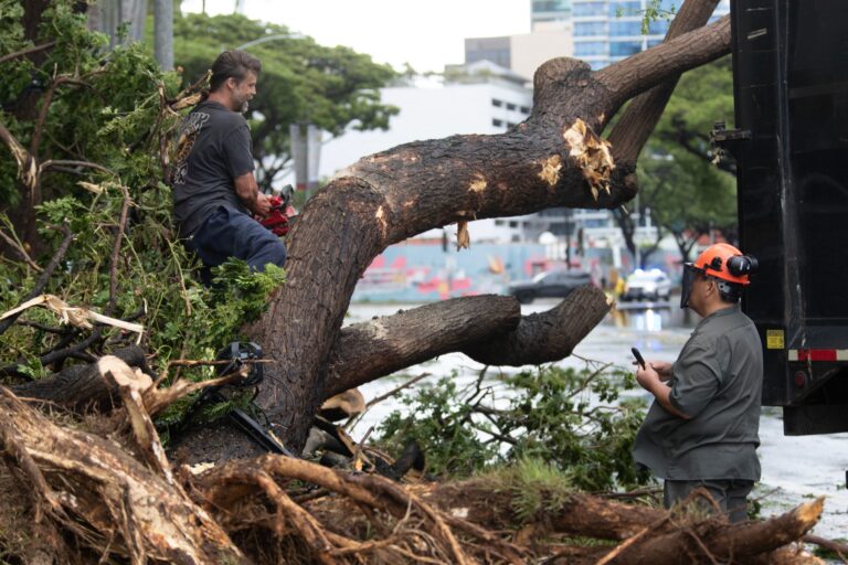
Workers cut a fallen tree into pieces in front of the Hawaii Convention Center, knocked down from rain and wind from Hurricane Lala, in Honolulu, Hawaii, on August 16, 2026. Eugene Tanner/AFP via Getty Images
Tropical Storm Moke is not a hurricane. It will almost certainly stay a tropical storm as it tracks south of the Hawaiian Islands this weekend. And that fact — reassuring in an ordinary August — means almost nothing to the communities that spent the last eight days digging out from Hurricane Lala, because the ground beneath their feet has changed everything.
When saturated soil can no longer absorb water, rain stops filtering down and starts running off immediately — and the National Weather Service’s own documentation from earlier this year shows what that looks like in Hawaii: a weaker second storm that produced more severe flooding than the stronger first one. That is what Moke is arriving into. The NWS March 2026 event summary details exactly this sequence.
As of early Sunday morning, the Central Pacific Hurricane Center placed Moke’s center near 15.3°N, 152.1°W — still roughly 360 miles (579 km) south-southeast of Hilo — moving west-northwest at about 12 mph (19 km/h), with maximum sustained winds of approximately 46 mph (74 km/h). The NHC Advisory 11 for Moke confirms forecasters do not expect it to reach hurricane strength. That is not the issue.
The issue is the 5 to 10 inches of rain — with up to 15 inches (38 cm) in isolated mountain areas — falling on Big Island terrain where Hurricane Lala already deposited more than 43 inches (109 cm) in some locations just eight days ago. The NHC Advisory 6 rainfall forecast makes the life-threatening nature of that combination explicit.
Why Weaker Can Still Mean Worse: Saturated Soil and the Flood Amplifier
To understand why Moke is genuinely dangerous despite its modest wind speed, it helps to know what Hurricane Lala left behind — not in terms of damage, but in terms of soil.
Hawaii’s volcanic soils are rich in iron and aluminum oxides and are normally quite porous, allowing heavy rains to filter through rather than run off. According to Hawaii volcanic soils March 2026 data compiled after the spring floods, under ordinary conditions that porosity is one of the things that makes the islands livable through wet seasons. But porosity has a limit — and Lala exceeded it dramatically. At Laupahoehoe Natural Area Reserve on the Big Island’s northeast coast, 43.55 inches fell between August 14 and 16, setting a Laupahoehoe 43.55 inches rainfall record. In Kapalua on Maui, the weekend total reached 48 inches (122 cm), according to CBS News Moke coverage.
Once volcanic soil is fully saturated, it cannot absorb more water. Subsequent rainfall — any subsequent rainfall — converts almost entirely to surface runoff instead of infiltrating. This is what hydrologists call the “saturation excess” mechanism, and its consequences are well-documented. A NOAA flood frequency antecedent moisture study found that for fully saturated soil conditions, a 7-year precipitation event can trigger what would normally be a 100-year flood. A Nature Communications February 2026 study confirmed that antecedent soil moisture is the leading control on runoff efficiency across nearly four-fifths of studied catchments — more important than storm intensity alone. Research published in the Journal of Hydrometeorology found that once soils exceed a critical saturation threshold, peak streamflow during a storm is on average two to four and a half times larger than under drier conditions — the USGS nonlinear streamflow study findings that established this relationship cover 89% of West Coast watersheds studied.
This is not a theoretical concern for Hawaii. The National Weather Service’s Honolulu office documented exactly this phenomenon earlier this year, in March 2026. After a powerful Kona low soaked the islands from March 10–16, a weaker atmospheric trough arrived from March 19–24. The NWS March 2026 event summary states the result plainly: while the main atmospheric features of that event were weaker than the recent Kona storm and the rainfall less widespread, the impacts were more severe due to the already-saturated ground from the previous week requiring less rainfall to result in runoff and flooding. In North Shore communities on Oahu, that second, weaker storm swept away homes and vehicles and prompted mass rescues.
Moke is arriving in the same position — the second storm, the weaker one — eight days after a storm that dropped three to four feet of rain on the Big Island’s windward slopes.
What the NHC Is Warning
The National Hurricane Center has been explicit. Its public advisory states that this rainfall may produce life-threatening flooding and mudslides for the windward and southeast Big Island, especially in steep terrain and over areas that were affected recently by Lala. The NHC Advisory 6 rainfall forecast includes that specific language about terrain affected by Lala.
The warning language — “especially in steep terrain and over areas that were affected recently by Lala” — is a direct acknowledgment of the saturation effect. USGS and NWS landslide hazard data both confirm that on Hawaii’s steep volcanic slopes, soil saturation from a prior storm dramatically lowers the rainfall threshold that triggers landslides. The KHON2 landslide hazard guidance compiled from USGS and NWS sources explains that when slopes are already near or at saturation, even moderate rainfall rates can initiate slope failures without warning.
Moke’s center is expected to pass south of the Big Island during the overnight hours of Sunday into Monday, then continue west-northwest toward the remaining islands through early Tuesday. Little change in Moke’s strength is expected before passage, with gradual weakening beginning Sunday as it encounters increasing wind shear and drier air to the west, according to NHC Discussion 9 wind shear.
Casey Oswant, a meteorologist with the NWS Honolulu office, acknowledged the limits of the relief Moke’s weakening provides: “There will still be impacts, especially to the windward and southeast sides of the Big Island, but it will probably be a little bit more limited than what we saw with Lala.” The phrase “a little bit more limited” describes a storm’s rainfall totals, not its flood potential — which, on Lala-saturated ground, does not scale proportionally with precipitation.
Triage Mode, Storm Fatigue, and What Moke Finds on Arrival
Hawaii County opened emergency shelters on Saturday and canceled bus routes across the Big Island. The Hawaii Emergency Management Agency reactivated its joint information center — just days after standing it down following Lala — according to CBS News Moke coverage.
Governor Josh Green has authorized 100 hotel rooms as emergency accommodations for residents who cannot shelter safely at home. In a video statement Saturday, he warned that the compound threat may not end with Moke. “This storm will be followed by another storm front about a week later,” he said, “and we continue to see the impacts of these major weather fronts that have hit Hawaii.”
Maui County Mayor Richard Bissen named the problem directly: “We know many in our community are experiencing storm fatigue and still recovering from last weekend’s weather system. Recent impacts from Tropical Storm Lala mean that even light to moderate rain and wind could trigger flooding, debris, downed trees, roadway issues and power outages.”
Storm fatigue is not just an emotional challenge — it affects decision-making in ways that matter for survival. Emergency managers describe it as a documented phenomenon in compound-disaster sequences: residents who correctly prepared for the first storm are more likely to underweight the second one, especially when the second storm is objectively weaker. The soil saturation mechanism means that intuition — “Moke is a tropical storm, Lala was a hurricane, so Moke is safer” — is exactly the wrong guide to risk in this situation.
An additional complication: parts of the Hawaii Volcanoes National Park area lie within Moke’s impact zone, and the County of Hawaii has noted that if Kīlauea erupts during the storm, Highway 11 would be restricted to area residents only, according to Al Jazeera Kilauea Highway restriction reporting.
El Niño: Why Hawaii’s Historic Shield Is Down
For decades, Hawaii’s near-immunity to tropical cyclones rested on two physical realities: cooler sea-surface temperatures north and west of the islands that robbed approaching storms of fuel, and strong vertical wind shear that tore apart organized tropical systems before they could threaten land. Both conditions have been undercut by the 2026 El Niño.
El Niño — a periodic warming of the central and eastern Pacific Ocean — simultaneously reduces the vertical wind shear that normally breaks storms apart and warms the ocean surface that feeds them. Ocean temperatures ahead of Lala’s passage ran approximately 3 degrees Fahrenheit (1.7°C) above the seasonal average, providing enough fuel to sustain a Category 1 hurricane until it reached the Big Island’s shores, as Weather Channel Lala ocean temperatures documented. The same El Niño is producing what NOAA has identified as an above-average 2026 central Pacific hurricane season, with five to thirteen named cyclones forecast, per NOAA above-average Pacific season forecast.
The Weather Channel back-to-back storms reported that back-to-back storms threatening the Hawaiian Islands in a single week has been observed only once before in the record going back to 1950. It is an event whose historical rarity is now being tested against a background state — El Niño-amplified Pacific — that makes it less rare.
The Atlantic, meanwhile, has experienced the inverse: with El Niño flooding the tropical Atlantic with hostile wind shear, the basin had gone deep into August without its first hurricane, well past the historical average first-hurricane date of August 11.
What Residents Should Know Before Moke Passes
For residents in the Big Island’s windward and southeastern communities, the guidance from emergency officials is specific:
The primary hazard is not wind — Moke’s tropical-storm winds, while gusty in exposed mountain areas, are not the concern that its wind classification might suggest. The primary hazard is rainfall on soil that is already at or near saturation — meaning flash flooding and mudslides can occur faster, with less rain, and on slopes that held during Lala. Anyone in a low-lying area, near a stream or river, on a steep hillside, or in an area that experienced flooding, landslides, or road damage during Lala should treat the Moke rainfall warning as equivalent to a higher-intensity event than Moke’s category alone implies.
Emergency shelters are open on the Big Island and Maui. Hawaii County Civil Defense can be reached at (808) 935-0031. One hundred hotel rooms have been authorized as emergency accommodations by Governor Green for those who need them.
Swells generated by Moke are also expected to affect exposed east- and south-facing shores of the Hawaiian Islands through early next week, with NHC life-threatening surf warning conditions possible. Residents and visitors should stay away from east- and south-facing shorelines.
Power restoration from Lala remains ongoing across the Big Island, with some remote Hāmākua corridor communities not expected to have electricity restored until September 8 per Hamakua power restoration September 8 projections. Communities still without power face compounded risk — no electric water pumps, no refrigeration for medications, and reduced capacity to monitor emergency communications — when Moke’s rain arrives.
Frequently Asked Questions
Why is Moke considered life-threatening when it is only a tropical storm, not a hurricane?
Moke’s danger comes not from its wind speed but from where its rain will fall. When soil is fully saturated — as it is across much of the Big Island after Hurricane Lala dropped 40-plus inches of rain eight days ago — rainfall no longer infiltrates into the ground. Instead, nearly all of it becomes immediate surface runoff. Research from a NOAA flood frequency amplification study shows that under fully saturated soil conditions, a precipitation event that would normally produce a 7-year flood can instead produce a 100-year flood — a 14-fold amplification. The NWS Honolulu office documented this exact phenomenon in Hawaii in March 2026: a weaker second storm caused more severe flooding than the stronger first storm because the ground could absorb nothing. Tropical-storm-category rainfall is not “safe” on ground this saturated.
Has this pattern — a weaker storm flooding worse because of a prior storm — actually happened in Hawaii before?
Yes, and recently. In March 2026, a Kona low soaked the islands from March 10–16. When a weaker atmospheric trough followed from March 19–24, the NWS March 2026 event summary recorded that it produced more severe impacts than the first storm specifically because of the already-saturated ground from the previous week requiring less rainfall to result in runoff and flooding. Homes and vehicles were swept away on Oahu’s North Shore in the second, weaker event. The Lala-Moke sequence is structurally analogous, at larger scale.
Why is Hawaii seeing so many storms in such a short time?
The 2026 El Niño is the primary driver. El Niño warms the central Pacific Ocean and simultaneously weakens the vertical wind shear that would normally tear apart approaching tropical systems — removing two of the mechanisms that have historically protected Hawaii. NOAA had forecast an above-average 2026 central Pacific hurricane season before the season began, citing El Niño’s influence, as covered in the prior TechTimes article on NOAA above-average Pacific season forecast. Governor Green has specifically warned that the storm activity may not end with Moke, with another weather system potentially arriving within a week, per his Green another storm front warning.
What should I do if I am in a flood-prone area when Moke passes?
Do not rely on Moke’s tropical-storm classification as a guide to your flood risk. If your area experienced flooding, mudslides, or road damage from Lala, treat Moke’s rainfall as potentially more dangerous in those locations, not less. Move to higher ground or a shelter before rain begins — saturated-soil flooding can develop faster than on dry ground, and streams and rivers can rise with little warning. Hawaii County emergency shelters are open; call Hawaii County Civil Defense at (808) 935-0031. Avoid driving through any standing water — the NWS Turn Around Don’t Drown principle applies with particular urgency on ground that is already saturated.