HomeAuto ISRO Launches EOS-05: Satellite Reads Mineral Dust, Crop Stress, Fire Every 5 Minutes
ISRO Launches EOS-05: Satellite Reads Mineral Dust, Crop Stress, Fire Every 5 Minutes
September 5, 2026:
Isro.gov.in
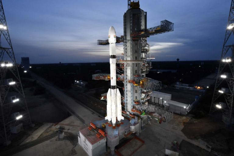
India’s space agency ended a seven-month launch drought in the pre-dawn hours of Friday when a GSLV-F17 rocket lifted EOS-05 — the country’s first geostationary imaging satellite — off the Second Launch Pad at the Satish Dhawan Space Centre and placed EOS-05 into orbit. What makes the satellite scientifically and operationally unusual is not just that it stares continuously at the Indian subcontinent from 36,000 km (22,369 miles) up — it is that it carries a 256-channel short-wave infrared (SWIR) hyperspectral imager operating from geostationary orbit, a sensor configuration that remains rare globally and one that India has never before had available.
The rocket lifted off at 2:55 a.m. IST (9:25 p.m. ET Thursday, September 3) and the 2,367-kilogram (5,218 lb) satellite separated from the third stage approximately 18 minutes and 40 seconds after launch, per the GSLV-F17 mission brochure. “I am very happy to announce that the GSLV-F17 vehicle has successfully and precisely injected the Advanced Earth Observation Satellite 05, the geo-imaging satellite, in the intended and required orbit,” ISRO Chairman V. Narayanan said at ISRO’s post-launch press conference, adding that the satellite’s health was “perfectly alright.” Mission Director Thomas Kurian called it “a moment of pride for the entire team” and noted EOS-05’s “near-real-time imaging capability” as the milestone the GSLV program had built toward.
What Hyperspectral Imaging from Geostationary Orbit Actually Enables
Standard multispectral satellites — the bread and butter of Earth observation — split incoming light into a handful of broad color bands: red, green, blue, and near-infrared, typically between three and ten channels. That is enough to map vegetation, estimate crop density, and identify large water bodies. A hyperspectral imager does something categorically different: it divides the same incoming light into hundreds of narrow, contiguous bands, each measuring reflected energy in a slice of the electromagnetic spectrum just a few nanometers wide. The result is a spectral “fingerprint” for every pixel in the image — a profile that can identify specific materials, not just general categories.
EOS-05 carries three distinct imaging instruments:
A multispectral visible/near-infrared (VNIR) imager with six channels covering 0.45–0.875 micrometers at 42 meters (138 ft) ground resolution — the finest spatial detail EOS-05 can resolve and the mode most useful for high-resolution land mapping.
A hyperspectral VNIR imager with 158 channels, each 4 nm wide, covering 0.375–1.0 micrometers at 318 meters (1,043 ft) resolution. At 158 channels, this sensor can distinguish between plant species, estimate chlorophyll concentration, and detect early-stage crop stress by looking for subtle shifts in how vegetation reflects in the red-edge spectral region.
A hyperspectral SWIR imager with 256 channels, each 7 nm wide, covering 0.9–2.5 micrometers at 191 meters (626 ft) resolution. This is the sensor that makes EOS-05 genuinely unusual. The SWIR portion of the spectrum (roughly 1,000–2,500 nm, or 0.9–2.5 micrometers) is where most of the world’s major mineral, soil, and atmospheric diagnostic features appear. Carbonate minerals absorb energy at approximately 2.0 micrometers; clay minerals show characteristic absorption at around 2.2 micrometers; iron oxides produce a feature near 1.0 micrometer. Liquid water in vegetation and soil creates strong absorption at about 1.4 and 1.9 micrometers. Methane, water vapor, and certain industrial gases show SWIR hyperspectral instrument specs absorption signatures as well. A sensor that resolves 256 narrow bands across this range can do what a broadband imager cannot: tell not just that a region of land is dry, but specifically which molecular water content threshold the soil has crossed, or whether smoke over a fire zone contains particular combustion gases.
Why Doing This from Geostationary Orbit Is Rare
Most hyperspectral satellites operate from low Earth orbit — 500–600 km (311–373 miles) above the surface — where the proximity yields enough photons per pixel to produce good signal-to-noise ratios in narrow spectral bands. Italy’s PRISMA satellite, Germany’s EnMAP, and the former NASA EO-1 Hyperion are all LEO hyperspectral instruments. From LEO, a hyperspectral sensor passes over any given point on Earth once every one to three days, producing a data product with high spatial resolution and high spectral resolution but fundamentally limited temporal resolution: if a wildfire starts at 3 a.m. between two passes, you miss four to six hours of its early development.
Geostationary orbit solves the temporal problem at the cost of resolution. From 36,000 km (22,369 miles), the photon flux per pixel is dramatically lower — the satellite must either use larger optics, settle for coarser spatial resolution, or both. EOS-05 does both: its 700mm Ritchey-Chretien telescope is the largest optical aperture ISRO has flown on an Earth-observation platform, and its hyperspectral resolution in SWIR (191 meters, or 626 ft) accepts a spatial penalty in exchange for the ability to stare at the same geography indefinitely.
The Ritchey-Chrétien design — the same optical configuration used in the Hubble Space Telescope and most of the world’s large ground-based observatories — uses a hyperbolic primary mirror and hyperbolic secondary mirror to eliminate the coma and spherical aberration that plague conventional Cassegrain designs across a wide field of view. ISRO based the design on its own Cartosat-2A telescope, scaling it up for GEO conditions. At the focal plane, array detectors split the collected light into the three imager modes simultaneously.
The tradeoff this enables is specific to disaster monitoring: for tracking a cyclone intensifying over the Bay of Bengal, mapping a flood front advancing across the Brahmaputra valley, or detecting an emerging wildfire in the Western Ghats, knowing what is happening right now matters far more than having a sub-10-meter image from several hours ago. EOS-05 can image any selected region of India every five minutes and images entire Indian landmass every 30 minutes. No other Indian satellite offers this.
GSLV Mk II Delivers Its Heaviest Payload to GTO
Friday’s mission marked the 19th flight from Sriharikota of India’s Geosynchronous Satellite Launch Vehicle (GSLV) and the 107th orbital launch from the Satish Dhawan Space Centre. Narayanan noted that when the first GSLV flew on mission D1, its geostationary transfer orbit (GTO) payload capability stood at approximately 1,536 kg (3,386 lb); GSLV-F17 injected 2,367 kg (5,218 lb) — a 54% increase that reflects the progressive improvements made to the vehicle’s cryogenic upper stage. That GSLV’s D1 payload comparison marks one of the most tangible demonstrations of ISRO’s engineering progress over two decades.
The vehicle is 51.7 meters (169.6 ft) tall, weighs 420.5 tonnes (927,177 lb) at liftoff, and uses three distinct propulsion technologies in sequence, per the GSLV-F17 official mission brochure. Its first stage combines a solid-propellant core motor (S139, burning HTPB solid propellant) with four liquid-fueled strap-on boosters (each an L40H engine burning UH25 and nitrogen tetroxide). The second stage uses an indigenous Vikas liquid engine. The third stage — and the one that has defined the GSLV’s history — is the CE-7.5 cryogenic engine, burning liquid hydrogen (LH2) stored at -253°C (-423°F) and liquid oxygen (LOX) at -183°C (-297°F). Cryogenic propellants deliver the highest specific impulse of any chemical propellant combination in operational use; only six countries have independently developed and flown CE-7.5 cryogenic engine history, and India, which achieved its first confirmed cryogenic success in January 2014, is the most recent.
The CE-7.5 had a troubled record before its current success streak. An anomaly in the cryogenic stage caused the loss of EOS-05’s predecessor, GISAT-1 (EOS-03), in August 2021, when the GSLV-F10 cryogenic stage failure prevented the satellite from reaching orbit. After a redesign and qualification campaign, the engine achieved six consecutive successful missions between 2017 and July 2025 (GSLV-F14 through F16, including the NISAR joint launch with NASA). Friday’s seventh consecutive CE-7.5 success places the vehicle in a different reliability category than the one it inhabited through 2021.
Returning from a Difficult Stretch
The GSLV-F17 launch is ISRO’s first orbital success since July 2025 and ends a seven-month gap that followed two consecutive failures on a different vehicle: the Polar Satellite Launch Vehicle (PSLV).
PSLV-C61 third-stage failure occurred on May 18, 2025, when a manufacturing defect in the third-stage solid motor’s graphite nozzle throat insert caused a chamber pressure drop, preventing the EOS-09 radar imaging satellite from reaching orbit. ISRO investigators identified the cause, switched to a carbon-composite nozzle material, and flew PSLV-C62 on January 12, 2026. That mission also failed at the same stage: a roll-rate disturbance near the end of the third-stage burn sent the vehicle off course, costing 16 satellites including the DRDO’s EOS-N1 hyperspectral imaging payload and payloads from Brazil, Spain, the United Kingdom, and France — the first time a PSLV failure had destroyed foreign commercial satellites.
These were PSLV failures, not GSLV failures. The two vehicles share launch infrastructure at Sriharikota but use entirely different propulsion architectures. The PSLV’s PS3 is a solid-propellant motor; the GSLV’s GS3 is a liquid-hydrogen/liquid-oxygen cryogenic engine. The two failure modes are unrelated, and ISRO treated them as separate investigations.
Applications: What SWIR from GEO Opens Up
SpaceKidz India’s Srimathy Kesan, founder and CEO of SpaceKidz India Limited, described the combination as enabling “detailed analysis of vegetation health, crop stress, soil moisture, mineral composition, snow and glacier dynamics, coastal processes, and atmospheric conditions.” Each of those applications depends on a different region of EOS-05’s 256-channel SWIR spectrum.
Crop stress and agricultural monitoring: Water stress in crops — insufficient irrigation, drought, or root-zone dehydration — produces measurable changes in the 1.4 and 1.9 micrometer water absorption bands before any visible wilting appears. A hyperspectral SWIR imager scanning every 30 minutes can provide Indian agricultural extension services with near-daily updated stress maps across every major growing district, timed to the stages of a growing season when intervention is still effective.
Mineral and geological mapping: India contains extensive mineral resources — iron ore in Jharkhand and Odisha, bauxite in the Eastern Ghats, coal across the Deccan plateau. Airborne SWIR hyperspectral surveys exist for specific areas, but they require repeated flight campaigns. EOS-05 offers persistent synoptic mapping: changes in exposed mineral surfaces due to mining activity, erosion, or dust transport will be detectable in near-real time over the entire country simultaneously.
Wildfire and industrial heat detection: Hot surfaces emit strongly in the SWIR bands beyond approximately 1,600 nm, well above the background thermal radiation of cool ground. A wildfire front advancing through a forest will stand out in specific SWIR channels as a thermal anomaly distinct from the vegetation it is burning — allowing automated fire detection algorithms to identify fronts at 191-meter (626 ft) resolution, updated every five minutes during active burn conditions.
Atmospheric column measurements: Several atmospheric gases — including water vapor, methane, and carbon dioxide — absorb SWIR radiation at specific wavelengths. Integrated column measurements of atmospheric composition are currently done from LEO (by instruments like GOSAT and OCO-2), but with revisit limitations. EOS-05’s persistent coverage over the Indian subcontinent offers a complementary data stream for regional greenhouse gas monitoring over one of the world’s most rapidly industrializing economies.
What Comes Next
EOS-05 is not yet at its final operational position. GSLV-F17 placed the satellite into a Sub-Geosynchronous Transfer Orbit with a perigee of 170 km (106 miles) and an apogee of 28,934 km (17,977 miles), per the GSLV-F17 mission brochure. Over the coming weeks, the satellite’s onboard propulsion system will execute a series of apogee motor firings to progressively raise and circularize the orbit until it reaches the operational geostationary slot at approximately 35,786 km (22,236 miles) above the equator. After that, an instrument commissioning period will follow before the first operational images are downlinked.
Narayanan signaled at a post-launch press conference that ISRO intends to move quickly: six more launches this year are planned before the current financial year ends in March 2027. That schedule includes NVS-03 — a navigation satellite targeting a NVS-03 November 2026 target that India’s NavIC positioning system urgently needs. NavIC currently operates with only three functional positioning satellites, one fewer than the four required for reliable three-dimensional fixes across its coverage region. EOS-05’s success clears the manifest for NVS-03 to proceed.
Prime Minister Narendra Modi called the launch “yet another outstanding achievement by ISRO and a proud moment for our nation,” crediting EOS-05 with reflecting “the excellence, innovation and growing capabilities that define” India’s space program. For the engineers who watched GISAT-1 lost over the Bay of Bengal in 2021 when the CE-7.5 engine failed to ignite — and then spent five years preparing this second attempt — Friday morning’s clean separation and confirmed orbital health will have marked something more specific than national pride: unfinished business, finally finished.
Frequently Asked Questions
How is EOS-05’s hyperspectral SWIR imager different from the imaging sensors on India’s other Earth-observation satellites?
India’s existing remote-sensing fleet — the Resourcesat, Cartosat, and RISAT series — operates from low Earth orbit at 500–600 km (311–373 miles), producing high-resolution images (0.5–50 meters) but revisiting any single location only once or twice a day. Those instruments use multispectral sensors: a handful of broad spectral bands, typically three to ten. EOS-05’s 256-channel SWIR hyperspectral imager resolves the electromagnetic spectrum from 0.9 to 2.5 micrometers into 256 narrow, 7-nanometer-wide slices, allowing specific materials — minerals, crop water status, atmospheric gases, combustion products — to be identified by their spectral fingerprint rather than simply categorized by brightness or color. Combined with geosynchronous persistence, it can update those identifications for priority zones every five minutes rather than every 24–48 hours.
Why does hyperspectral imaging work so much better at short-wave infrared wavelengths than at visible wavelengths for certain applications?
The short-wave infrared (roughly 900–2,500 nm) is where most of the fundamental molecular absorption features of materials important to agriculture, geology, and atmospheric science fall. Water molecules absorb strongly at 1,400 nm and 1,900 nm; silicate minerals at 2,200 nm; carbonates at 2,000 nm; iron oxides at 1,000 nm. At visible wavelengths (400–700 nm), most minerals and plant tissues look broadly similar — they reflect and absorb light in ways that differ at the level of hue and brightness. In SWIR, the same materials have sharp, chemically specific absorption features that act as fingerprints, allowing positive identification rather than probabilistic classification. That distinction is what makes SWIR hyperspectral data irreplaceable for mineral mapping, crop stress assessment, and fire detection.
Does EOS-05 replace any existing Indian satellite, or does it fill a gap that nothing else covered?
EOS-05 is a replacement for GISAT-1 (EOS-03), which was lost when GSLV-F10’s cryogenic stage failed to ignite in August 2021. Before that mission failed, no Indian satellite had operated from geosynchronous orbit for imaging purposes — India’s existing INSAT meteorological satellites provide weather data but with far coarser imaging resolution and without hyperspectral capability. EOS-05 fills a gap that has existed since the GISAT program was first proposed: continuous, near-real-time optical imaging of the Indian subcontinent with hyperspectral discrimination capability. It does not replace any currently operational satellite; it is the first operational instance of a capability India has never actually had.
What does EOS-05’s launch success mean for NavIC, India’s GPS alternative?
NavIC currently operates below its minimum threshold of four simultaneously visible satellites needed for reliable three-dimensional positioning. The fourth-generation replacement satellite, NVS-03, was waiting for ISRO’s launch infrastructure at Sriharikota to be cleared for its own GSLV mission. EOS-05 going first, and succeeding, removes the primary schedule constraint: NVS-03 is now targeting a November 2026 launch. A successful NVS-03 deployment would restore NavIC to minimum operational capability after more than six months below its functional floor, according to the NavIC below four-satellite floor reporting and NVS-03 November 2026 target confirmed by ISRO.