HomeAuto EarthCARE Satellite Finds Volcanic Ash 124 Miles From Krakatau, Challenging Aviation Safety Models
EarthCARE Satellite Finds Volcanic Ash 124 Miles From Krakatau, Challenging Aviation Safety Models
October 7, 2026:
NURUL HIDAYAT/gettyimages.com
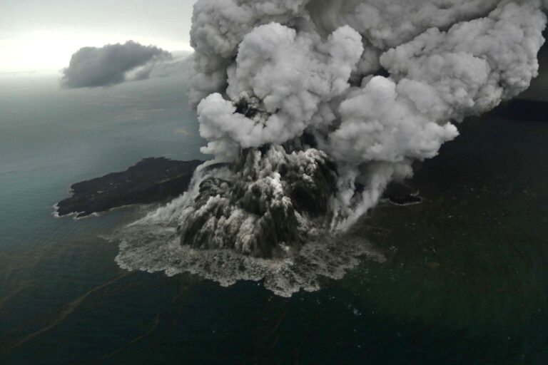
ESA’s EarthCARE satellite detected large volcanic ash aggregates sitting 200 km (124 miles) from Anak Krakatau and nearly 20,000 feet (6 km) in altitude — a finding that challenges the particle-sedimentation assumptions used in the global aviation safety models that draw hazard zones around eruption plumes.
Scientists presented the result on October 1, 2026, drawing on data the satellite collected on September 5 as it crossed overhead the day after Anak Krakatau’s major eruption began, grounding thousands of flights and stranding hundreds of thousands of passengers across the Indonesian archipelago. ESA released the findings October 1 after combining ATLID and CPR data, and the results are already being studied further by modelers at the European Centre for Medium-Range Weather Forecasts (ECMWF) and the University of Reading.
Anak Krakatau and Its Famous Inheritance
Anak Krakatau — Indonesian for “Child of Krakatoa” — sits in the Sunda Strait between Sumatra and Java, growing steadily from the seafloor since 1927. It rose from the same caldera that the catastrophic 1883 eruption of the original Krakatoa blasted open — the eruption that triggered a trans-oceanic tsunami and injected enough sulfate aerosols into the upper atmosphere to cause measurable global cooling for more than a year. A flank collapse in December 2018 shrank Anak Krakatau’s summit from more than 300 m (984 ft) above sea level to roughly 110 m (361 ft) and triggered a tsunami killing more than 400 people.
The volcano had been at alert Level III since July 2, 2026, when Indonesian authorities escalated monitoring after a sustained uptick in seismic activity. On September 4, eruptions intensified dramatically. By the following morning, the Indonesian Geological Agency confirmed the eruption was still ongoing, ash columns visible to the west and the red glow of the eruption plume visible in darkness from monitoring posts. Indonesia’s meteorological agency, BMKG, identified ash plumes at two altitude bands — up to 20,000 feet (6,100 m) moving northeast over Jakarta and Banten, and up to 50,000 feet (15,240 m) moving westward over the Indian Ocean. Authorities issued 18 Significant Meteorological Information bulletins (SIGMETs) to aviation during the event.
What an Ordinary Satellite Cannot See
The global network of nine Volcanic Ash Advisory Centres (VAACs) relies on a combination of weather-radar data, meteorological modeling, and satellite imagery to draw ash hazard zone boundaries that tell airlines where they cannot safely fly. The Darwin VAAC, operated by Australia’s Bureau of Meteorology Darwin VAAC (BOM), holds responsibility for the region that includes Indonesia and immediately took on the Anak Krakatau eruption.
Most of those satellite tools capture the volcanic plume from above — photographing its horizontal spread, color, and the intensity of sulfur dioxide signatures. They cannot look inside. They provide a top-down picture but leave the vertical architecture of a plume largely uncharacterized until instruments like ground-based lidar or research aircraft can sample it. ESA’s guidance notes that passive imaging tools lack vertical penetration — a limitation EarthCARE was designed to overcome.
That is precisely what EarthCARE — the ESA and JAXA joint mission launched in May 2024 — was built to change. Though designed primarily to study how clouds and aerosols regulate Earth’s radiation balance, the satellite carries a suite of four instruments profiling atmosphere vertically in ways no prior operational spacecraft could match.
Two Instruments, One Cross-Section
EarthCARE’s most consequential instrument for the Krakatau observation was ATLID — the ATmospheric LIDar. ATLID fires 355-nanometer ultraviolet laser pulses toward Earth and measures the light that scatters back. By using a high-spectral-resolution design that distinguishes between Mie scattering (off particles) and Rayleigh scattering (off molecules), ATLID’s algorithms can classify aerosol type by altitude — separating ash from sulfate, smoke, sea salt, and desert dust by how each one scatters light differently.
ATLID’s companion for the Krakatau observation was EarthCARE’s Cloud Profiling Radar (CPR), contributed by JAXA and the National Institute of Information and Communications Technology (NICT). The CPR operates at millimeter-wave 94 GHz — approximately 3 mm wavelength — which makes it sensitive to large particles (ice crystals, large ash aggregates) rather than the fine aerosols ATLID excels at resolving.
Together, on September 5, they produced what scientists described as a “vertical curtain” — a cross-section of the Anak Krakatau plume showing altitude-by-altitude distributions of optically thin sulfate, optically thick sulfate, fine ash, and what appears to be coarse ash, all in separate layers. The composite image, overlaid on a Copernicus Sentinel-3 optical capture from the same date, showed the plume’s structure at a level of detail no single prior instrument could have achieved.
What the Models Get Wrong: Ash That Travels Farther Than Expected
The most scientifically significant finding came from the CPR’s radar signal, not from ATLID’s laser.
Robin Hogan, a principal scientist at ECMWF whose team collaborated with ESA on the analysis, explained the discovery plainly. “Normally we would expect the particles in a volcanic plume 200 km from the source to be too small to be detected by a radar,” Hogan said in the ESA release. “However, thanks to the unprecedentedly high sensitivity of the CPR, it detects a feature extending from the surface up to around 6 km (19,685 ft), which is believed to correspond to larger ash aggregates that are settling out of the plume.”
Standard volcanic ash dispersion models used by VAACs worldwide assume that coarse ash — the larger, heavier fragments and aggregated clusters formed when fine particles clump together in a plume — falls out of the atmosphere relatively quickly and relatively close to the eruption source. Those assumptions are built into VAAC physics parameters that determine where the models place their hazard-zone boundaries. A coarse ash signal at 200 km (124 miles) from the source, at altitudes up to 6 km (3.7 miles), is precisely the kind of observation that suggests those parameters may be set incorrectly.
Helen Dacre, a volcanic ash dispersion specialist at the University of Reading whose model is central to the UK Met Office’s aviation safety forecasts, identified the implication directly. “If confirmed, this would provide useful evidence that large ash particles can remain aloft for longer, and travel farther, than is often assumed,” Dacre said. “The observation, therefore, offers a valuable opportunity to constrain both ash sedimentation rates and long-range transport processes in volcanic ash dispersion models.”
Ash aggregation — the process by which fine volcanic particles cluster into larger structures during atmospheric transport — has been studied for years as a potential source of systematic error in VAAC models. Research by the University of Geneva found that these aggregated clusters, dubbed “cored clusters,” can behave unexpectedly — sometimes settling faster than individual particles, sometimes slower. Current VAAC operational models largely do not account for aggregation physics. The EarthCARE CPR observation is the first real-time spaceborne radar confirmation of coarse aggregate presence far downwind of an eruption at operational aviation altitudes, providing evidence that can now be used to revise those parameters.
Where Neither Instrument Could See
The radar finding was not the only scientifically significant feature of the September 5 observation. A large region of the plume near its upper levels was shaded in what scientists described as a “gray zone” — airspace where ATLID’s laser beam was fully attenuated by an optically thick sulfate layer it could not penetrate, while the CPR lacked the sensitivity to detect fine ash in the same region.
The gray zone is a direct consequence of the complementarity principle that makes EarthCARE powerful: the same thickness that makes a sulfate layer opaque to a lidar beam is also the condition under which fine ash cannot be reliably inferred from a radar return. What is in that gray zone cannot currently be determined from this observation alone.
ESA’s message to aviation authorities about the uncertainty was unambiguous: even when the instruments cannot say what is there, the uncertainty itself is the hazard. Aircraft should not enter a gray zone simply because a radar returned no signal indicating ash. No signal from a lidar-blocked region is not the same as no ash in that region.
Verified at 15 Kilometers: The Upper-Atmosphere Picture
While the coarse ash radar signal captured the lower tropospheric story, ATLID was simultaneously verifying the upper-atmosphere component of the plume — a westward-moving layer of sulfate material reaching FL500.
“Together with the VAAC forecasters, we were able to verify the forecast guidance of the westward moving plume at FL500, which is at the altitude of around 15 km (49,213 ft),” said Andy Prata of BOM. “ATLID was crucial to help forecasters verify the altitude of the upper-level component of the plume.”
FL500 is roughly 49,200 feet (15 km) above Earth — the boundary of the stratosphere, where aerosols are not removed by rain or weather and can circulate globally for months. Most commercial aircraft cruise at FL350 (35,000 ft / 10,700 m); FL500 is well above operational cruising altitude. But sulfate aerosols injected into the stratosphere carry a separate concern: their long-term residence time in the upper atmosphere means they can affect Earth’s radiation balance far beyond the duration of any individual flight disruption.
Shannon Mason, also of ECMWF, described how EarthCARE’s real-time data stream enabled that stratospheric assessment. “The separate, layered and interacting plumes of ash, clouds, gases and aerosols from volcanic eruptions are complex and evolve rapidly,” Mason said of the near-real-time assessment. “With a timely observation from EarthCARE we were able to grasp the vertical structure of this event in near-real time to inform aviation advice — and scientists will continue using EarthCARE’s measurements to better understand how ash and other volcanic aerosols behave in the hours and days after an eruption.”
From Aviation Safety to Climate Science
The Anak Krakatau data set has a significance beyond the immediate flight-safety application. ESA atmospheric scientist Alex Hoffmann drew the longer line: “While immediately challenging for aviation, the impacts of major volcanic eruptions can be much longer lasting,” Hoffmann said in the ESA release. “Sulphate aerosols injected into the stratosphere by the 1883 Krakatoa eruption persisted for more than a year, reflecting incoming sunlight and causing temporary global cooling. Understanding the injection altitude of volcanic material and its optical properties is particularly important to understand climate impacts — information that EarthCARE’s lidar is well positioned to provide.”
The September 2026 eruption extended a track record EarthCARE has been building since it became fully operational in July 2024. In 2024, ATLID data contributed to the first published peer-reviewed study of stratospheric aerosol transport from Indonesia’s Mount Ruang eruption — work led by Sergey Khaykin and colleagues and published in Atmospheric Chemistry and Physics in early 2026. That study found the Ruang eruption produced eruptive columns reaching 25 km (82,021 ft) in altitude and temporarily doubled the tropical stratospheric aerosol abundance for several months.
The Anak Krakatau dataset is now being analyzed further, with modelers working to confirm the coarse ash identification and constrain the sedimentation physics the radar signal implies. The gray zone remains an open scientific question.
What is not in question is the capability that produced the data. EarthCARE was built to study the climate. When Anak Krakatau erupted on September 4, 2026, the satellite demonstrated that the same instruments designed to characterize how clouds and aerosols regulate Earth’s energy balance can simultaneously provide aviation authorities with vertical atmospheric intelligence that no prior spaceborne tool could deliver in near-real time.
Frequently Asked Questions
Why might current aviation safety models draw ash hazard zones too small?
Volcanic ash dispersion models used by the nine Volcanic Ash Advisory Centres worldwide calculate how far ash particles will travel based on assumptions about how quickly different particle sizes fall out of the atmosphere. Those assumptions have historically not fully accounted for ash aggregation — the process by which fine particles clump together into larger structures during atmospheric transport, which can behave differently from individual particles. EarthCARE’s Cloud Profiling Radar detected coarse ash aggregates 200 km (124 miles) from Anak Krakatau at altitudes up to 6 km (19,685 ft), where current models would predict the particles to be too small and too sparse to register. If confirmed through further modeling, this observation would require modelers to revise sedimentation rate and transport parameters — potentially widening hazard zones in some eruption scenarios.
How does EarthCARE see inside a volcanic plume when other satellites cannot?
Most operational satellites capture volcanic plumes passively — imaging the top of the cloud or measuring sulfur dioxide concentrations in two dimensions. EarthCARE carries active instruments: ATLID fires ultraviolet laser pulses and measures the returning backscattered light to build altitude-by-altitude profiles of aerosol type and concentration, while the Cloud Profiling Radar uses millimeter-wave radar sensitive to large particles. Together they produce a “vertical curtain” cross-section of the plume — showing what is at each altitude across the entire column, rather than just what can be seen from above. No prior operational satellite combined both active lidar and active radar for this purpose.
What is the “gray zone” in the EarthCARE Krakatau observation, and why does it matter for aviation?
The gray zone is a section of the plume where neither of EarthCARE’s primary instruments could characterize what was present. A thick layer of sulfate aerosols blocked ATLID’s laser from penetrating further, while the Cloud Profiling Radar could not detect fine ash in that region. The scientific uncertainty about what the gray zone contains is itself an aviation hazard: a radar that returns no signal from a lidar-blocked region does not confirm the absence of ash — it confirms the absence of data. ESA and aviation authorities communicated this plainly: aircraft should not fly through regions where the instruments cannot confirm the airspace is clear.
How long can volcanic ash linger in the stratosphere?
At tropospheric altitudes (below approximately 12 km / 39,370 ft), rain and turbulent mixing remove ash and aerosols within days to weeks. In the stratosphere, where Anak Krakatau’s upper plume reached (around 15 km / 49,213 ft or FL500), particles are above the weather and can persist for months to years. Sulfate aerosols from the 1883 Krakatoa eruption remained in the stratosphere for more than a year, scattering incoming sunlight and causing measurable temporary global cooling. EarthCARE’s ATLID instrument can measure the altitude and optical properties of stratospheric aerosols with high precision, giving scientists data they need to assess whether a given eruption’s stratospheric injection is large enough to affect climate on a regional or global scale.