HomeAuto Rodgers Creek Fault Tops Bay Area Quake Odds: 250 Years of Silence, Still Locked
Rodgers Creek Fault Tops Bay Area Quake Odds: 250 Years of Silence, Still Locked
September 6, 2026:
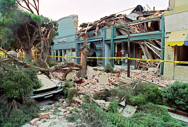
Rubble fills the sidewalk in front of a street mall in Santa Clara 18 October 1989 in San Franciso after a quake rocked the city 17 October, killing an estimated 63 people and doing USD 1 billion-worth of damage. JONATHAN NOUROK/AFP via Getty Images
A magnitude 3.5 earthquake shook the Santa Rosa area on Thursday, September 3, centered near the Rodgers Creek Fault — a fault that has not produced a single major documented earthquake in more than 250 years of California’s recorded history, despite strong scientific evidence that it has ruptured at magnitude-7 or greater before, and is likely overdue to do so again.
That silence is not reassurance. Paleoseismic research — the study of prehistoric earthquakes through trench excavations and radiocarbon-dated displaced rock layers — has confirmed, per Hecker et al. 2005 BSSA, that the most recent large Rodgers Creek Fault rupture occurred somewhere between A.D. 1715 and 1776, involving roughly 6.6 feet (2 meters) of surface slip consistent with an approximately M7 earthquake. As of 2026, approximately 250 to 311 years have passed since that event. The fault’s preferred average recurrence interval — the typical time between its major earthquakes, based on the same trench data — is approximately 230 years. The elapsed time has reached and likely exceeded that average. The Rodgers Creek Fault is not merely in a long quiet period. It is past its recharge window.
The September 3 tremor was centered about 2 miles east-southeast of the unincorporated community of Larkfield-Wikiup and roughly 4 miles north of downtown Santa Rosa, at a depth of about 4.6 miles (7.4 km) below the surface — shallow enough to produce noticeable shaking across a wide area. Residents in Santa Rosa’s Fountaingrove and Coddingtown neighborhoods reported the strongest shaking; reports submitted to the USGS website showed felt effects as far south as Petaluma, and light vibrations reached San Francisco and Hayward. Sonoma County emergency officials confirmed no damage or injuries. Santa Rosa High School was briefly evacuated as a precaution but returned to normal operations within hours.
The quake arrived within days of a new set of earthquake probability calculations published by the U.S. Geological Survey — the first comprehensive update to the Bay Area’s 30-year forecast in over a decade. USGS research geophysicist Kevin Milner recalculated the figures using the same underlying model as the 2014 assessment (the third Uniform California Earthquake Rupture Forecast, or UCERF3) but with a 2026 start date, accounting for the additional years that have elapsed without a major rupture on each fault. The result: a 74.1% overall probability that somewhere in the Bay Area will experience a magnitude 6.7 or stronger earthquake in the next 30 years — up from 72% in the prior 2014–2043 forecast.
The Hayward-Rodgers Creek Fault System now carries the highest probability of any single Bay Area fault system: 34.3% for a major rupture over 30 years. The San Andreas Fault, which draws more popular attention, comes in second at 25.5%. “It’s reinforcing what we already know — that we have to be prepared for a major earthquake,” Milner told NBC San Diego. “It is going to happen in most of our lifetimes.”
What Makes Rodgers Creek Different From Every Other Major Bay Area Fault
The Bay Area’s major faults have histories. The Hayward Fault last ruptured in 1868 — 158 years ago, approaching the outer edge of its roughly 140-year average recurrence cycle. The San Andreas ruptured in 1906 and again, in its southern section, in 1989. The West Napa Fault produced a damaging M6.0 in 2014. Geologists can examine the damage records, the casualty counts, the rupture maps.
The Rodgers Creek Fault has no such history. In more than 250 years of California’s documented record — from the earliest Spanish Mission-era accounts through the present — the fault has not produced a single major, ground-rupturing earthquake. To a casual observer, that might sound like good news. To a seismologist, it sounds like a clock that has been running for a very long time without ringing.
The fault is a right-lateral strike-slip structure — the same mechanical category as the Hayward and San Andreas, meaning the Pacific Plate side moves northward relative to the North American Plate side — that runs about 63 miles (101 km) from just north of San Pablo Bay through the heart of Santa Rosa and continues to south of Healdsburg. Together with the Hayward Fault, to which it is physically connected beneath San Pablo Bay (a 2016 USGS discovery by geophysicist Janet Watt’s team), it forms a combined 118-mile (190 km) system capable of a simultaneous rupture reaching magnitude 7.4 — a scenario that would simultaneously devastate the East Bay and Sonoma County.
What makes the silence so significant is the mechanism behind it. Seismic risk accumulates when a fault is “locked” — when tectonic plate motion is not being gradually released through aseismic creep, but is instead building as elastic strain in the surrounding rock. InSAR satellite radar measurements of the Rodgers Creek Fault published in 2017 found that while the fault’s northern section (north of Santa Rosa, toward Healdsburg) shows some evidence of shallow surface creep, the southern section near and through Santa Rosa appears locked. A locked fault does not release its accumulated strain quietly. It releases it all at once.
The Geology Under Santa Rosa Makes Shaking Worse
The risk from a Rodgers Creek rupture is not evenly distributed across its length. Santa Rosa sits in a particularly hazardous position: directly over both the fault trace itself and the Cotati Basin — a depression in the underlying bedrock filled with soft, unconsolidated sediments that dramatically amplify seismic waves. This phenomenon, called site amplification, means that identical earthquake energy produces more intense surface shaking in sediment-filled basins than in solid rock.
The effect has been documented directly. In October 1969, a pair of earthquakes measuring M5.6 and M5.7 struck just north of Santa Rosa on the Healdsburg Fault, a closely related parallel structure linked to the Rodgers Creek system. The damage was, by the accounts of post-earthquake investigators, “greater than expected” for the magnitude — a result attributed specifically to the Cotati Basin concentrating shaking at Santa Rosa. The total damage reached $8.35 million (approximately $69.7 million in 2026 dollars), and at least 200 aftershocks followed. One person died.
A 2016 USGS lidar mapping study led by geologist Suzanne Hecker added a further complication: beneath the Rodgers Creek Fault’s pull-apart basin at the Santa Rosa Creek floodplain — the area created where a releasing bend in the fault causes the crust to stretch and subside — the team identified a dense, magnetic body of basement rock on the eastern flank of the fault. Hecker’s team interpreted this rock body as a “strong asperity” — a patch of higher frictional resistance on the fault where stress concentrates — and noted that it appears to be associated with the concentration of the 1969 aftershock cluster and with higher creep rates north of the city than to the south. An asperity that accumulates stress and sits beneath a basin that amplifies shaking is a structurally worrying combination for the city built on top of it.
Earthquake Fault: What ‘In the Zone’ Means for Santa Rosa’s Schools
California’s Alquist-Priolo Earthquake Fault Zone Act, signed into law on December 22, 1972 in the aftermath of the damaging 1971 Sylmar earthquake, prohibits the construction of new occupied structures directly over active fault traces and requires geologic investigation of any site within a designated fault zone before development can proceed. The California Geological Survey is responsible for maintaining and updating the fault zone maps — a living document augmented continuously as new mapping data arrives.
Four of Santa Rosa’s elementary schools sit within the Alquist-Priolo zone for the Rodgers Creek Fault: Proctor Terrace, Hidden Valley, Brook Hill, and the Santa Rosa French-American Charter School. Two of those campuses — Proctor Terrace and Hidden Valley — were newly placed inside the zone, following a California Geological Survey map update in 2024–2025 that used improved fault tracing to revise the zone boundaries. Prior maps had shown both campuses near, but not inside, the zone. That changed with the lidar-derived mapping data.
The reclassification triggered mandatory seismic investigations at both campuses, which Santa Rosa City Schools is conducting. The district has also closed Brook Hill Elementary (as of June 2024) and plans to relocate the Santa Rosa French-American Charter School from its Sonoma Avenue campus to a former middle school building several blocks away. The seismic studies are not emergency evacuations — district officials have stated there is no immediate safety danger at the affected campuses. But the Alquist-Priolo reclassification imposes real regulatory constraints on what can be built, renovated, or occupied on those sites until geological investigation defines and delineates the surface rupture hazard on a site-by-site basis.
For property owners in the broader area of the fault trace, the Alquist-Priolo zone also triggers mandatory disclosure obligations in real estate transactions — sellers and agents are required to inform buyers if a property lies within a designated earthquake fault zone.
How Do Scientists Know the Fault Has Ruptured Before?
This is where paleoseismology becomes central to the story — and to understanding why the Rodgers Creek’s silence is not the same as safety.
Scientists cannot watch what happened 300 years ago. But they can read it in the rock. Trenching — digging carefully excavated trenches perpendicular to the fault trace and examining the layers of sediment exposed on the walls — can reveal the record of past earthquakes in the form of displaced or tilted strata, sand-filled fissures, and abrupt changes in sediment deposition. Radiocarbon dating of organic material (charcoal, plant remains) found in disturbed layers provides age constraints on when the displacement occurred.
The landmark 2005 study by Hecker, Pantosti, Schwartz, and colleagues at the USGS — based on trenching at the Beebe Ranch site south of Santa Rosa — produced the most precise age estimate for the Rodgers Creek Fault’s most recent major earthquake: between A.D. 1715 and 1776 (the study’s preferred estimate, which narrows to A.D. 1690 to 1824 with maximum uncertainty). The amount of surface slip at the Beebe Ranch site — roughly 6.6 feet (2 meters) — is consistent with a magnitude-7 earthquake based on standard earthquake-scaling relationships. That places the Rodgers Creek in the same destructive league as the 1906 San Francisco earthquake (M7.9) and well above the 1989 Loma Prieta earthquake (M6.9) in terms of likely surface shaking.
The same study calculated a preferred average recurrence interval for major Rodgers Creek earthquakes of approximately 230 years (with a wide uncertainty range of 131 to 370 years). As of 2026 — 21 years after the 2005 study was published — the elapsed time since the last known major rupture is approximately 250 to 311 years. The elapsed time falls comfortably within the fault’s recurrence window and almost certainly meets or exceeds the mean recurrence interval. “The elapsed time may have reached or exceeded the average recurrence time for the fault,” the authors wrote in 2005. Two additional decades of waiting have only deepened that finding.
Importantly, the 2005 study also noted that the timing of the most recent Rodgers Creek earthquake overlaps with the timing of prehistoric surface ruptures on both the northern and southern sections of the Hayward Fault — raising the possibility that the two faults ruptured together as a single, combined event in the 18th century, which would have generated an earthquake significantly larger than either fault could produce alone.
What Would a Major Rupture Mean for Sonoma County?
No published USGS scenario study on the Rodgers Creek Fault matches the detail of the HayWired scenario for the Hayward, but regional modeling has produced estimates of the destruction a major Rodgers Creek rupture could cause. Modeling cited by the Press Democrat has projected that a major rupture could destroy more than 4,500 residential buildings, 9,500 commercial buildings, and roughly 1,700 government, religious, agricultural, and educational structures across Sonoma County. Critical infrastructure — hospitals, fire and police stations, aqueducts, and major road networks — would be among the hardest hit in a city whose older building stock includes unreinforced masonry structures.
The September 2022 M4.4 and M4.3 quakes near the same Larkfield area that produced Thursday’s tremor caused damage to several homes — a reminder that even moderate events on the fault produce real consequences at ground level. Those 2022 quakes, like Thursday’s M3.5, were far below what the Rodgers Creek is capable of.
Does a Small Earthquake Like Thursday’s Tell Scientists Anything New?
Thursday’s magnitude 3.5 event is, by earthquake standards, minor. Scientists consistently emphasize that small earthquakes of this scale do not meaningfully raise or lower the probability of a larger rupture — they are a background feature of seismic activity along any active fault, representing the routine release of tiny amounts of strain that have no direct predictive relationship to when the fault will rupture catastrophically. The September 3 quake does not, on its own, signal anything different about the Rodgers Creek Fault’s near-term behavior.
What it does signal — reinforced by the concurrent release of the 2026 USGS probability update — is that the fault is alive, active, and accumulating the stress that will eventually produce a major earthquake. Whether that earthquake comes in 10 years or 80 years is not something seismic science can currently predict. What science can say, with confidence, is that the structural preconditions for a major Rodgers Creek rupture are already in place: a locked southern fault segment, a sedimentary basin that concentrates shaking, hundreds of years of accumulated elastic strain, and a recurrence interval that the elapsed time has likely already met.
For Santa Rosa and Sonoma County residents, Thursday’s tremor is most useful as a practical prompt: check emergency supplies, understand the seismic status of your building, and recognize that the most dangerous fault in your immediate landscape is not the one that produced the 1906 earthquake or the 1989 one. It is the one that has been quiet long enough to be forgotten.
Is a Bay Area Earthquake in 30 Years a Near-Certainty?
The 74.1% overall probability figure is often misread as meaning a major Bay Area earthquake is essentially inevitable within a generation. The nuance matters. The figure is a conditional probability: it reflects the accumulated likelihood, across all major Bay Area faults, that at least one will produce a magnitude 6.7 or greater earthquake somewhere in the region between now and 2055. It is not a statement that any specific fault will rupture in a specific timeframe. USGS seismologist Ned Field, speaking to the SF Chronicle about the new figures, put the mathematical perspective plainly: for a fault that ruptures every 10,000 years, 10 years of waiting is “nothing” — the probability does not jump dramatically from year to year.
For the Hayward-Rodgers Creek system, the 34.3% figure is a 30-year window estimate derived from the fault system’s paleoseismic recurrence history and the time that has elapsed since its last major rupture. It does not mean a 34.3% chance in the next year, or even the next 10 years — it is a statement about risk accumulated over decades.
What makes the Rodgers Creek’s probability meaningful is the comparison to every other fault in the region. At 34.3% for the combined Hayward-Rodgers Creek system, no individual Bay Area fault system carries greater 30-year odds of a major rupture. The probability has risen since 2014 specifically because the years have continued to pass without a rupture — mechanically increasing the conditional probability the same way that each passing minute without a bus increases the probability the next one is due. The Rodgers Creek has been waiting for approximately 250 years. Its average wait between buses is about 230.
Frequently Asked Questions
When did the Rodgers Creek Fault last produce a major earthquake?
Paleoseismic research — specifically, trench excavations at a site south of Santa Rosa by USGS geologist Suzanne Hecker and colleagues — places the most recent large Rodgers Creek rupture between A.D. 1715 and 1776, with radiocarbon dating constraining the event to no earlier than 1690 and no later than 1824. That earthquake involved approximately 6.6 feet (2 meters) of surface displacement, consistent with a magnitude-7 event per Hecker 2005. No major ground-rupturing earthquake on the Rodgers Creek has been documented in the 250-plus years since. The fault’s preferred average recurrence interval is approximately 230 years — meaning the elapsed time has likely already reached or exceeded the average window between major ruptures.
What does a 34.3% probability in 30 years actually mean for residents?
It means that the Hayward-Rodgers Creek fault system — taken together — carries the highest probability of any single Bay Area fault of producing a magnitude 6.7 or stronger earthquake in the next 30 years. It does not mean a 34.3% chance in the next year, or that an earthquake is “scheduled.” The figure is a 30-year cumulative probability based on the fault system’s paleoseismic recurrence history and the time elapsed since its last major rupture. What it tells residents practically: if you live or work near the Rodgers Creek Fault and have not made earthquake preparedness a priority, the probability figures provide a concrete reason to do so now — not because a rupture is imminent, but because the structural risk is the highest of any fault in the region.
Why are four Santa Rosa schools in the earthquake fault zone?
The Alquist-Priolo Earthquake Fault Zone Act, a California law enacted in 1972 after the Sylmar earthquake, requires the California Geological Survey to map active fault surface traces and restricts new construction of occupied buildings within those zones. Four Santa Rosa elementary schools — Proctor Terrace, Hidden Valley, Brook Hill, and the Santa Rosa French-American Charter School — fall within the Rodgers Creek Fault’s Alquist-Priolo zone. Two of those (Proctor Terrace and Hidden Valley) were only placed inside the zone after a 2024–2025 update to the California Geological Survey’s fault maps, which incorporated more precise lidar-based fault tracing. The reclassification triggered mandatory seismic investigations at both campuses. Santa Rosa City Schools officials have stated there is no immediate danger at the sites, but the legal framework governing what can be built or occupied on the affected properties has changed.
What should Santa Rosa residents do to prepare?
The most important steps are practical and immediate. Determine whether your home or building sits within or near the Rodgers Creek Fault’s Alquist-Priolo zone — the California Geological Survey’s mapping tools allow address-level lookups. Store a minimum 72-hour supply of water and non-perishable food; water supply disruption is consistently cited by emergency managers as the most acute consequence of a major North Bay earthquake. Identify your building type — older unreinforced masonry structures and soft-story apartment buildings with open ground floors carry the highest collapse risk and may qualify for retrofit evaluation. Enable earthquake alerts on your phone (Android includes earthquake early-warning alerts automatically; iPhone users should confirm Emergency Alerts are enabled in Settings). When shaking begins: drop to your hands and knees, take cover under a sturdy table or desk, hold on until shaking stops, and protect your head and neck. Aftershocks typically follow any felt earthquake; a magnitude 3.5 will produce smaller aftershocks that diminish over time.