HomeAuto San Andreas Fault Is Moving Faster, Storing More Stress Than Scientists Knew
San Andreas Fault Is Moving Faster, Storing More Stress Than Scientists Knew
August 23, 2026:
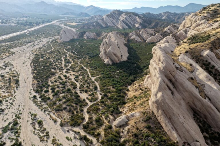
In an aerial view, the Mormon Rocks, uplifted by pressure from the San Andreas fault zone, are shown near the Cajon Pass on June 23, 2026 in Cajon Junction, California. Mario Tama/Getty Images
Two independent research teams examining opposite ends of California’s San Andreas Fault have arrived at the same unsettling conclusion in the same summer: earthquake risk along America’s most famous fault system is greater than scientists had previously modeled — in ways that matter to the roughly 30 million people who live within reach of its rupture zones.
The more immediately newsworthy finding comes from San José State University geologist Kim Blisniuk, whose research team has spent years mapping displaced landforms at Sanborn County Park near Saratoga — a quiet Santa Clara County reserve where the San Andreas Fault runs directly beneath the surface. Her unpublished findings, reported by the San Francisco Chronicle on August 20, 2026, show that the Santa Cruz Mountains section of the northern fault has been slipping faster than scientists believed, overturning a long-standing assumption about how plate motion distributes itself through the Bay Area fault system.
The second finding, published in June 2026 in the Journal of Geophysical Research: Solid Earth, comes from a team led by Dr. Liliane Burkhard of the University of Bern, with collaborators from the University of Hawaiʻi at Mānoa, the U.S. Geological Survey’s Earthquake Science Center in Pasadena, and the Scripps Institution of Oceanography. Their model, built from 1,000 years of earthquake history, finds that tectonic stress along the southern San Andreas and San Jacinto fault systems has now reached levels not seen at any point in the previous millennium — and that a key geographic junction northeast of Los Angeles is sitting in a configuration associated historically with multi-fault ruptures.
What a Faster Santa Cruz Mountains Slip Rate Means for the Bay Area
The Santa Cruz Mountains section of the northern San Andreas lies south of San Jose, placing it within close seismic range of Silicon Valley, the broader Bay Area, and several million people whose earthquake risk models have relied on specific assumptions about how quickly that section of the fault moves.
Blisniuk — a professor of geology at San José State — has spent years studying Sanborn County Park, where the fault has dextrally offset alluvial fans and debris flows away from their upstream sources by measurable distances over thousands of years. Her team used beryllium-10 cosmogenic nuclide exposure dating — a technique in which the accumulation of the isotope Be-10 in surface rocks, caused by cosmic ray bombardment, allows scientists to date precisely how long a landform has been exposed at the surface. By combining those depositional ages with the measured lateral offsets of the displaced features, the team reconstructed the fault’s average slip rate over roughly 10,000 years.
Previous research into this same stretch of fault had relied on records covering up to 1,000 years. Extending the window nearly tenfold, and rooting it in the geological record at Sanborn County Park, Blisniuk found that the Santa Cruz Mountains section’s slip rate does not decrease as one moves south from the North Coast section — contrary to a widely held hypothesis that plate motion transfers progressively onto neighboring faults such as the Calaveras or Hayward.
That hypothesis existed for a reason. The San Andreas Fault, which spans roughly 1,290 kilometers (about 800 miles) from the Salton Sea to the Mendocino Triple Junction, is not a single uniform structure. In Northern California, it branches and shares its load with a network of parallel faults, and scientists had assumed that the Santa Cruz Mountains section consequently carried less motion — and posed proportionally less hazard. Blisniuk’s data contradicts that: the slip rate appears to have remained broadly consistent across the 10,000-year timeframe.
Why does slip rate matter? In seismic hazard modeling, it is one of the primary ingredients in estimating how often a fault produces large earthquakes. A fault that slips at roughly 20 millimeters (0.79 inches) per year accumulates stress faster than one slipping at, say, 15 millimeters (0.59 inches) per year — and releases it more frequently. The UCERF3 statewide hazard model currently estimates a slip rate of 19-22 millimeters per year for the Santa Cruz segment. If Blisniuk’s findings survive peer review and indicate a higher or more sustained rate than those models assumed, they could affect earthquake probability estimates for the Bay Area.
The research is not yet published or peer-reviewed. The U.S. Geological Survey declined to comment on Blisniuk’s findings for that reason. Blisniuk herself has been careful to frame the result as a data update rather than an alarm. “This is not new movement,” she told reporters. “It’s new data — and a good reminder to be prepared.” She is expected to present the findings at a conference in October.
How Beryllium-10 Dating Reconstructs Thousands of Years of Fault Motion
The methodological core of Blisniuk’s research is worth understanding, because it represents a meaningful advance over shorter-timescale studies.
When a debris flow or alluvial fan deposits sediment near a fault, the rocks at the surface begin accumulating beryllium-10 — a rare isotope produced when cosmic rays strike silicon and oxygen atoms in surface minerals. The longer a rock sits exposed at the surface without being buried or eroded, the more Be-10 it contains. By measuring Be-10 concentrations in boulders from three different depositional units at Sanborn County Park — units derived from the Tertiary Vaqueros Formation — and matching those ages to the lateral distances those units have been offset by fault motion, the team was able to calculate how fast the fault has moved per year.
The approach requires careful attention to erosion rates, shielding from other materials, and the possibility that some Be-10 accumulated before the rocks were deposited (called “inheritance”). All published slip rates carry uncertainty ranges for this reason. But extending the record to 10,000 years provides a substantially more robust baseline than studies anchored to the last millennium — smoothing out the variability that single earthquake cycles can introduce into shorter-window measurements.
Southern California: Cajon Pass and the “Earthquake Gate”
While Blisniuk’s work illuminates the northern end of the fault, the Burkhard team’s June 2026 paper focuses on the southern San Andreas and its closely parallel neighbor, the San Jacinto Fault Zone — a system running from San Bernardino County through Riverside and Imperial Counties that is considered the most seismically active fault zone in Southern California.
Their model simulated 1,000 years of earthquake history across both systems to reconstruct how stress has accumulated. The findings are striking: the San Jacinto-Bernardino section currently shows modeled stress of 3.6 megapascals (MPa) — equivalent to roughly 520 pounds per square inch — exceeding any value recorded during the entire 1,000-year simulation. The neighboring Mojave South section of the San Andreas stands at 2.8 MPa. Both values are high relative to their historical ranges, and that relative similarity is itself a concern.
“Not only is it concerning that the stresses are reaching historic highs,” Burkhard said, “but also that the relative stress conditions between the two fault systems are approaching the range we associate with major ruptures crossing both faults simultaneously — and that is a scenario with much larger consequences for the region.”
The scenario Burkhard describes hinges on a specific geographic feature the researchers call an “earthquake gate”: Cajon Pass, the mountain gap northeast of Los Angeles where the San Andreas and San Jacinto faults converge to within approximately 1.5 kilometers (about 0.9 miles) of each other. Whether a large earthquake remains confined to one fault or propagates across both depends heavily on what happens at this junction.
The historical record shows that the gate has swung both ways. The Fort Tejon earthquake of 1857, a magnitude-7.9 event that ruptured approximately 350 kilometers (217 miles) of the central and southern San Andreas, stopped at Cajon Pass and did not cross to the San Jacinto Fault. In contrast, the Wrightwood earthquake of 1812 is thought to have crossed the gate — beginning on the San Jacinto Fault and propagating onto the San Andreas, producing what researchers now describe as a joint rupture of both systems.
What is less widely known is how often this cross-gate behavior occurs. A 2022 USGS multicycle dynamic model study found that co-ruptures through Cajon Pass — events in which both fault systems fail as a single earthquake — have occurred in approximately 20-23% of historical large earthquake sequences at this junction, making them unusual but far from rare. The Burkhard team’s finding that both the San Andreas and San Jacinto sections are simultaneously near historically unprecedented stress levels is significant precisely because it places the system in a configuration where cross-gate events are more likely.
An earthquake that ruptures both fault systems through Cajon Pass would subject the greater Los Angeles area, San Bernardino, Riverside, and the Coachella Valley to levels of shaking significantly greater than a single-fault event. Cajon Pass itself is the site of Interstate 15 — the main artery connecting Southern California to Las Vegas — as well as Union Pacific freight rail lines, natural gas pipelines, and fiber optic telecommunications infrastructure.
Burkhard was direct about what the study does and does not show. “The study is not a prediction of when an earthquake will occur. What we can say is that the system is critically stressed and that physics-based models like ours give a clearer picture of the range of scenarios we should be prepared for. This information is important for hazard assessment, infrastructure planning, and emergency preparedness.”
Two Studies, One Picture
The convergence of Blisniuk’s Northern California findings and the Burkhard team’s Southern California modeling in the same summer is notable independent of whether the studies are related — they study different sections of the same fault system using different methods.
Blisniuk said as much. Combining physics-based stress modeling with geological evidence and more than a thousand years of earthquake history “represents a more robust way to understand how stress accumulates along faults,” she told reporters. “This is now a model that really shows that we are really late in the earthquake cycle and an earthquake will rupture in our lifetime.”
That sentence — “in our lifetime” — comes from a geologist whose professional caution about prediction is well documented. Neither she nor Burkhard’s team claim to know when the next major rupture will occur. But understanding how fast the fault is moving, and how much stress has accumulated, is exactly what allows scientists to estimate the range of scenarios California should be planning for.
The USGS ShakeOut scenario, published in 2008, estimated that a magnitude-7.8 earthquake on the southern San Andreas could cause approximately 1,800 deaths and $213 billion in damage. A cross-gate multi-fault rupture at Cajon Pass would represent a substantially more severe scenario than that baseline.
What Californians Can Do Right Now
The science is clear on the preparedness case even when the timing is not. Standard earthquake preparedness guidance from California’s Governor’s Office of Emergency Services includes: securing heavy furniture and water heaters to walls, storing at least three days’ worth of water (at least one gallon/3.8 liters per person per day) and non-perishable food, identifying the location of the gas shutoff valve, and maintaining a household communication and reunification plan.
Residents and businesses can check their exposure to active fault zones using the California Geological Survey’s Alquist-Priolo Earthquake Fault Zone maps, which are available online through the state’s EQ Zapp portal.
As Blisniuk framed it: this is not about a new threat, and it is not about predicting a date. It is about new data — and what data demands.
Frequently Asked Questions
Does a faster slip rate mean an earthquake is coming soon?
Not in the sense of a specific date or time frame. A higher slip rate means a fault accumulates the displacement it must eventually release more quickly — which raises the statistical probability of a large earthquake over a given time window, according to standard seismic hazard models. But earthquake timing on individual faults cannot be predicted. Blisniuk’s research, still awaiting peer review, would — if confirmed — affect the probability estimates used in California’s official hazard maps, potentially showing the Santa Cruz Mountains section as somewhat more hazardous than current models indicate.
What is an “earthquake gate” and why does Cajon Pass matter?
An earthquake gate is a geographic junction where two major fault systems converge closely enough that a rupture on one can cross over to the other. Cajon Pass, northeast of Los Angeles, is where the San Andreas and San Jacinto faults come within roughly 1.5 kilometers (0.9 miles) of each other. When a large earthquake crosses this gate — as the 1812 Wrightwood earthquake apparently did — the resulting event ruptures both fault systems simultaneously, producing a significantly larger and more widespread quake than a single-fault rupture. The Burkhard team’s 2026 modeling finds that the current stress configuration on both fault systems approaches conditions historically associated with cross-gate events.
What should I do if I live near the San Andreas or San Jacinto faults?
Prepare as if the earthquake is overdue — because, on the longer historical timescale, it may be. That means securing heavy furniture and water heaters to walls with earthquake straps, stocking a minimum three-day supply of water (one gallon/3.8 liters per person per day) and non-perishable food, knowing where and how to shut off your gas, and establishing a household communication plan that does not depend on phone networks staying operational. The California Governor’s Office of Emergency Services maintains updated guidance and preparedness resources at the Cal OES earthquake portal.
How does the beryllium-10 dating method differ from shorter-term earthquake records?
Most earthquake slip rate studies use records covering a few centuries to a thousand years — enough to capture several earthquake cycles on an active fault. Beryllium-10 cosmogenic dating can extend this window to tens of thousands of years by measuring the accumulation of the isotope Be-10 in surface rocks, which builds up at a known rate when exposed to cosmic radiation. A longer baseline reduces the distortion that can come from studying only a few earthquake cycles, which may cluster in time by chance. Blisniuk’s 10,000-year record at Sanborn County Park provides a substantially more stable estimate of the Santa Cruz Mountains fault’s long-term slip rate than prior shorter-window studies — though all such estimates carry uncertainty ranges tied to erosion rates, rock shielding, and other variables.