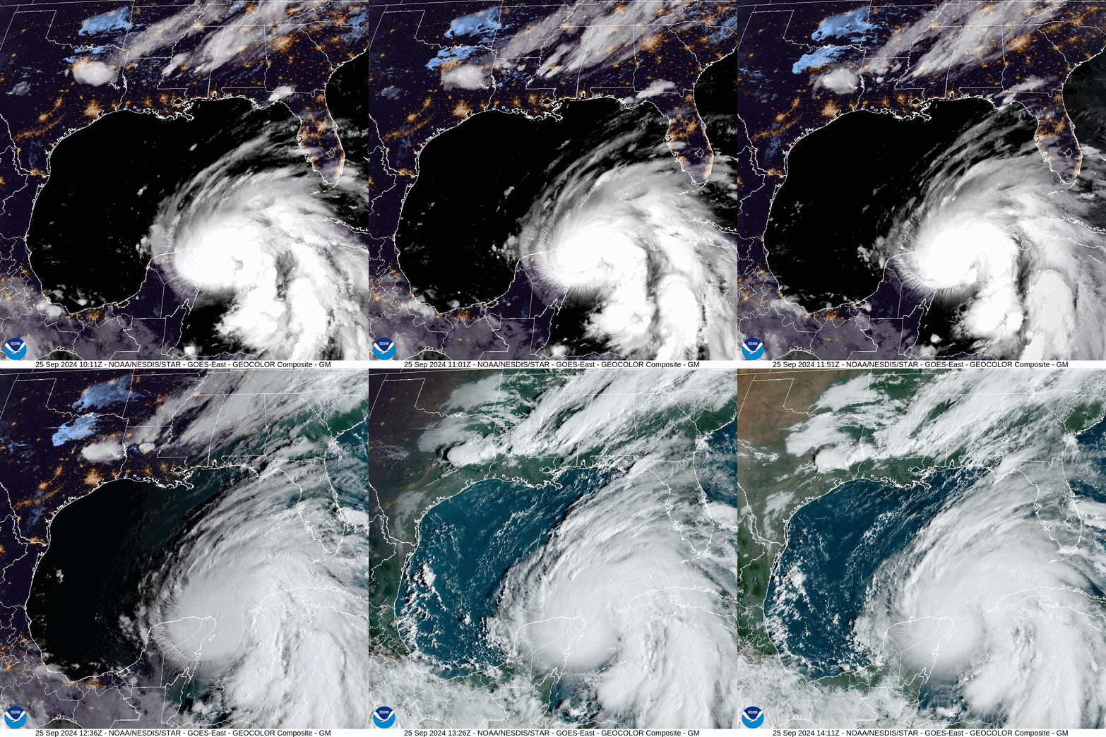
An enormous tropical storm named Helene, now a Category 1 hurricane, is churning across the Caribbean near Cuba and Mexico’s Yucatan Peninsula. Forecasters predict the hurricane — which as of Wednesday morning has maximum sustained winds of 80 miles per hour — will rapidly intensify in the next 24 hours before ramming into western Florida late Thursday as a monstrous storm.
“There is a danger of life-threatening storm surge from Tropical Storm Helene along the entire west coast of the Florida Peninsula,” the National Hurricane Center said early Wednesday morning.
The National Hurricane Center predicts storm surge as high as 15 feet in some parts of Florida’s Big Bend, a region between the panhandle and the peninsula. Caused largely by wind pushing water inland, storm surge is the most dangerous part of tropical storms; it killed more than 40 people during Hurricane Ian in 2022.
Helene could also disrupt part of the epic monarch butterfly migration, which typically passes through the Big Bend’s St. Marks National Wildlife Refuge in early October.
Hurricane Helene churns across the Caribbean.NOAA
Helene is the eighth named storm in what has so far amounted to a somewhat puzzling hurricane season. It started with a bang — June’s Hurricane Beryl became the earliest Category 5 storm on record — and then much of August and September was unexpectedly quiet.
Many meteorologists, though, have been warning not to be fooled by this late-summer lull.
“Having multi-week periods of quiet and then multi-week periods of activity is very normal throughout a hurricane season,” Brian McNoldy, a climatologist at the University of Miami, told me earlier this month. “I definitely would not read too much into it.”
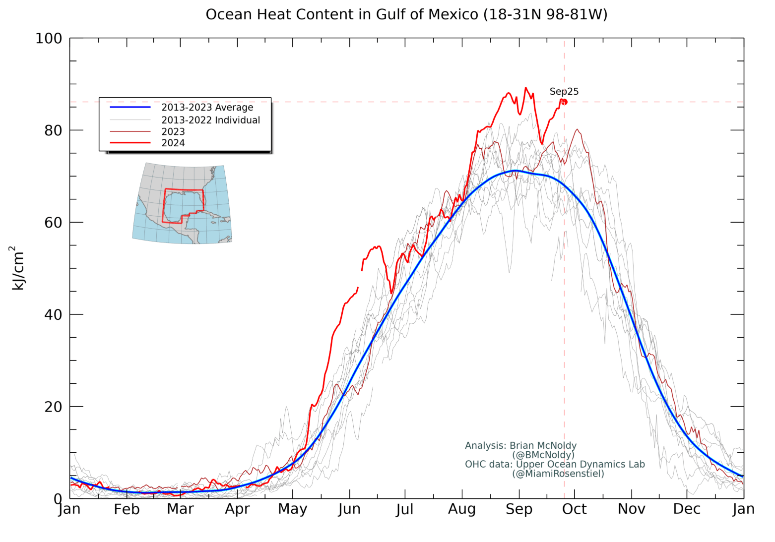
Plus, McNoldy said, the ocean in the Gulf of Mexico has been — and still is — exceptionally hot, and hot water fuels hurricanes. Ocean heat content, a measure of how much heat energy the ocean stores, is at a record high for this time of year.
Take a look at the chart below. The red line is 2024 and the blue line is the average over the last decade.
This is especially concerning right now, given the forecasted path of Helene.
All that ocean heat could supercharge the storm as it travels across the Gulf on its way to Florida, potentially causing it to “rapidly intensify.” That’s when wind speeds increase by roughly 35 mph or more in less than 24 hours. Forecasters predict that Hurricane Helene could hit Florida as a Category 3 or 4 system.
“The sea surface temperature and the ocean heat content are both record high in the Gulf,” McNoldy, who produced the chart above, told me. “That heat at the surface and available through a depth will give Helene all the fuel it needs to rapidly intensify today and into tomorrow.”
The record Gulf temperatures are just one signal of a more widespread bout of warming across the North Atlantic that ramped up last year.
It’s not entirely clear what’s causing this warming, though scientists suspect a combination of factors including climate change — which raises the baseline ocean temperature — as well as lingering effects of El Niño, natural climate variability, and perhaps even a volcanic eruption.
“This is out of bounds from the kinds of variability that we’ve seen in [at least] the last 75 years or so,” Ben Kirtman, director of the Cooperative Institute for Marine and Atmospheric Studies, a joint initiative of the University of Miami and the National Oceanic and Atmospheric Administration (NOAA), told Vox in August. “That can be scary stuff.”


![ROSE IN DA HOUSE I BE MY BOYFRIENDS 2 [OFFICIAL TRAILER]](https://cherumbu.com/wp-content/uploads/2022/01/ROSE-IN-DA-HOUSE-I-BE-MY-BOYFRIENDS-2-OFFICIAL-150x150.jpg)

